Methane Hotspots Research (AB 1496)
Assembly Bill No. 1496, Chapter 604, Section 39731 (Thurmond, 2015)
In 2015, the Governor approved Assembly Bill 1496 (AB 1496) which requires CARB to do the following:
- Undertake monitoring and measurements of high emission methane "hot spots"
- Life‑cycle greenhouse gas emissions analysis of natural gas produced and imported into California
- Review and assess the atmospheric reactivity of methane as a precursor to the formation of photochemical oxidant
- Update relevant policies and programs to incorporate new information
Background
A recent analysis of satellite data conducted by scientists from National Aeronautics and Space Administration (NASA) and the University of Michigan found a large methane “hot spot” over the Central Valley in California, and this was likely the second largest “hot spot” over the entire United States. Other areas of the State also have enhanced methane concentrations. These atmospheric methane enhancements were persistent over the 2003-2009 period and emphasize the need to identify the many contributing sources throughout the State for an effective emission mitigation program.
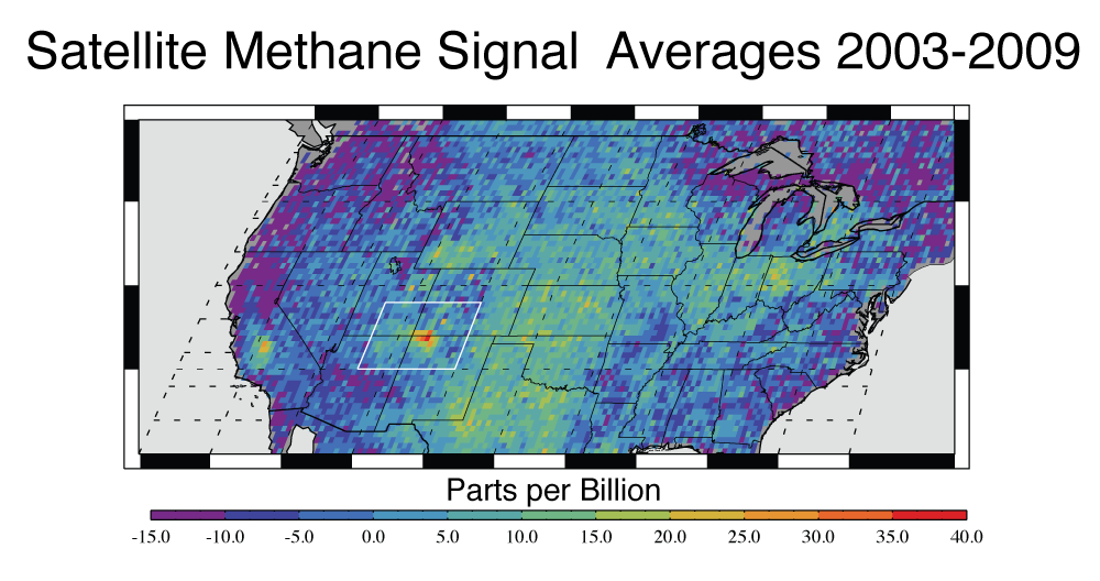
Kort, E. A., C. Frankenberg, K. R. Costigan, R. Lindenmaier, M. K. Dubey, and D. Wunch (2014), Four corners: The largest US methane anomaly viewed from space, Geophys. Res. Lett., 41, 6898–6903, doi:10.1002/2014GL061503.
Image obtained from joint news release.
Although CARB has a detailed list of methane source location and distributions throughout the State, there are several challenges in controlling the methane "hot spot". Methane is emitted from a variety of emission sources, including dairies, landfills, oil and gas activities, rice cultivation, industrial activities, and transportation sources, as well as naturally occurring oil and gas seeps.
- The California Department of Food and Agriculture (CDFA) estimates there are over 76,400 farms and ranches and over 1,470 dairies in California.
- CDFA estimates that California has over 1.79 million milk-producing cows, and the average milk production per cow in 2014 was estimated at 23,702 pounds.
- The California Division of Oil, Gas, and Geothermal Resources (DOGGR) estimates that about 210,000 oil, gas, and geothermal wells have been drilled in California since the petroleum industry began in the 1860s, and about 88,500 of the wells are still in use.
- The California Department of Resources Recycling and Recovery (CalRecycle) and CARB estimate that there are currently over 372 landfills in the State that contain and/or receive biodegradable, carbon-bearing waste.
- Emission behavior of different sources is highly variable by season, temperature, feed, age, operations, maintenance, etc.
- Methane “hot-spots” may be caused by a large number of very small sources, a small number of very large sources, or a combination
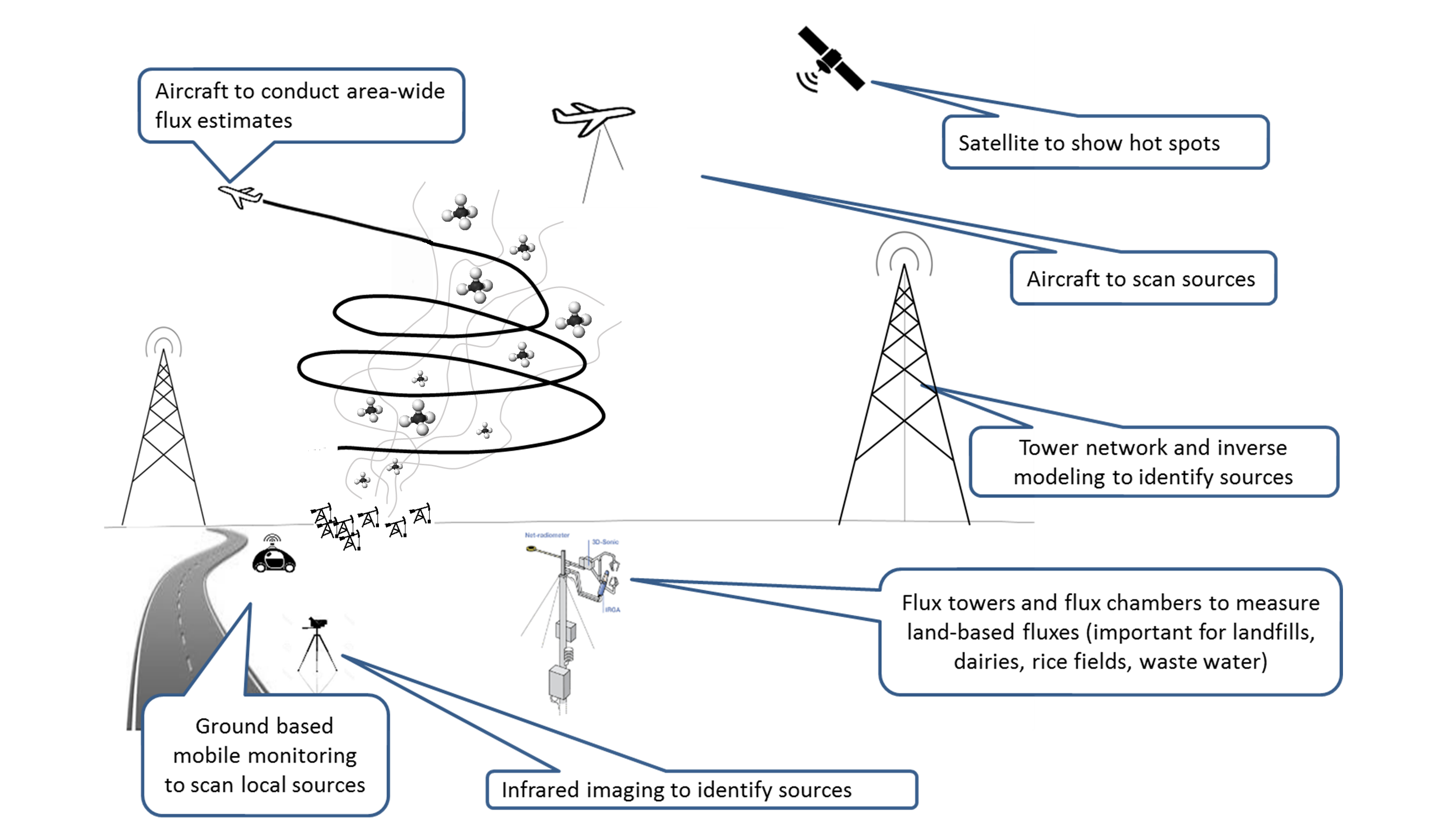
Tiered Observation System
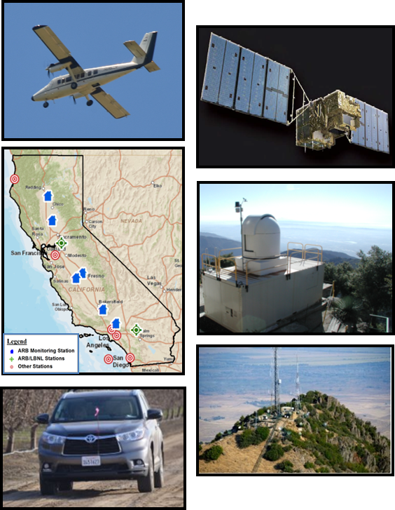 In order to meet the requirements under AB 1496, and broadly under Assembly Bill 32 (2006) and Senate Bill 32 (2016), CARB and the various research collaborators are implementing a "Tiered Observation System" to conduct measurements at many different scales to identify emission sources:
- Satellite-based remote sensing
- Broad, coarse identification of high-methane regions
- Augmented by facility locations, emission inventory, Statewide GHG Monitoring Network, and modeling
- Aircraft-based remote sensing
- Total methane flux by source region with tracers for limited source type identification
- Identification of individual methane plumes
- Ground verification
- Mobile methane monitors and infrared cameras
- Flux measurements
- Regional Inventory Analysis
- CARB Statewide GHG Monitoring Network
- Air Quality Modeling
The various research tools will be functioning in close collaboration with each other to study the regional, local, and source-level methane emission profiles. A general pictographic representation of the research tools is shown below:
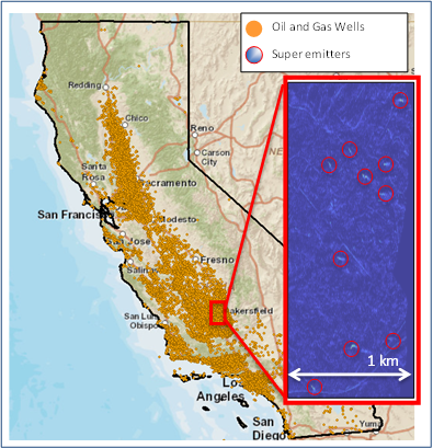 Large Localized Methane Emission Sources
 Large Localized Methane Emission Sources
There is also growing evidence in the recent scientific literature suggesting that a small fraction of methane sources within a category may be responsible for the majority of the emissions. Recent research suggests >50% of methane emissions may come from <10% of sources, and these “large localized sources” may be a large contributor to the regional methane “hot spots”. However, these sources are generally not concentrated in a small region, but instead are distributed across the State. Moreover, some of these methane sources may have intermittent emission behavior. Therefore, there is a critical need to utilize aircraft monitoring and other remote sensing approaches to consistently and comprehensively survey methane emission sources throughout California.
AB 1496 Research Efforts
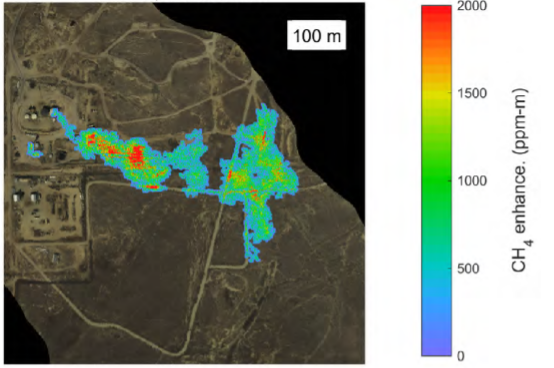 Statewide Methane Survey
 Statewide Methane Survey
A key component of CARB's research effort is a large-scale statewide aerial methane survey conducted by NASA Jet Propulsion Laboratory (JPL), through funding from CARB and CEC. The project focused on identifying and mitigating large localized sources of methane, and utilized an imaging camera capable of seeing methane to visually identify large methane plumes throughout the State. The first comprehensive survey was conducted during the Fall of 2016, and covered approximately 30,000 square kilometers, and identified many of the largest methane sources in the State. A second field campaign was completed in the Fall of 2017. The survey captured sources in all important methane source sectors, including:
- Oil and Gas - production/processing, storage, transmission, distribution
- Agriculture - dairies, manure, rice fields
- Waste - landfills, waste water
Resources
- California Methane Survey - Phase II Final Report
- California Methane Survey - Phase I Interim Report
- Staff Presentation to the Board on California Statewide Methane Survey (September 2017)
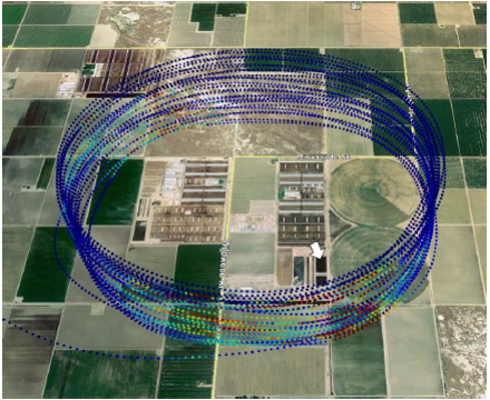 Airborne Facility-Level Methane Emissions Study
 Airborne Facility-Level Methane Emissions Study
CARB also contracted with Scientific Aviation, which was responsible for the quick-response airborne measurements during the Aliso Canyon gas leak incident, to perform airborne measurements to quantify facility-level methane emission fluxes from important emission sources throughout California. Scientific Aviation uses small planes with sensitive methane and meteorological monitors to quantify total facility-wide methane emission rates (as opposed to imaging of individual methane sources done by JPL) by flying concentric circles of varying elevations and/or upwind and downwind measurements around the sites of interest. This information is complementary to the JPL imaging research, and collectively, provided useful information to both identify sources and quantify their emission rates. In addition, this research also allowed to quantify facility-level methane emission rates from large diffused sources (e.g. dairies, landfills, rice cultivation, etc.). The project surveyed selected high methane emission facilities in South Coast, San Joaquin Valley, Sacramento Valley, Bay Area and Northern California from the following sectors: agriculture, energy, waste management and natural sources.
Resources
- Statewide Airborne Methane Emissions Measurement Survey - Phase I
- Statewide Airborne Methane Emissions Measurement Survey - Phase II
Research Outcomes
These projects have helped identify several large localized methane emission sources, including:
- Leaks in oil & gas infrastructure
- Leaks in landfill infrastructure
- Large emissions from dairy lagoons
- Malfunctioning emission control equipment, etc.
In addition, these research efforts will have multiple program connections, including:
- Improving understanding of emission sources and emission estimation
- Develop and inform new methane control programs (e.g. dairies, oil and gas, landfills)
- Identify location and behavior of unknown sources (e.g. abandoned wells)
- Enforcement of current and future programs (e.g. oil and gas regulations)
- Inform natural gas infrastructure leak prevention/detection/mitigation efforts (post-Aliso Canyon)