Arvin/Lamont
- Communities
- Community Air Protection
- Community Recommendations
- Consistently Nominated Communities
- Selected Communities in the Program
- Arvin, Lamont
- Bayview Hunters Point/Southeast San Francisco
- Calexico, El Centro, Heber
- East Los Angeles, Boyle Heights, West Commerce
- East Oakland
- Eastern Coachella Valley
- International Border Community
- North Imperial Phase 1
- Portside Environmental Justice Neighborhoods
- Richmond - San Pablo
- San Bernardino, Muscoy
- Shafter
- South Central Fresno
- South Los Angeles
- South Sacramento - Florin
- Southeast Los Angeles
- Stockton
- West Oakland
- Wilmington, Carson, West Long Beach
Contact
Overview
- Selection year: 2021
- Selected for: Community Air Monitoring Plan and Community Emissions Reduction Program
- Air District: San Joaquin Valley Air Pollution Control District
- Latest events: Air District web page for Arvin/Lamont
- CARB Community Lead Contact: Michelle Byars
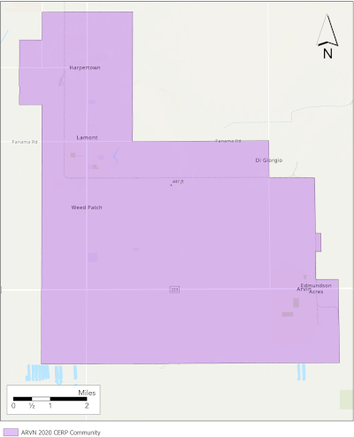
The Arvin/Lamont Community is at the southern end of the San Joaquin Valley Air Pollution Control District (SJVAPCD) in South Kern County. The cities of Arvin and Lamont are small, rural communities. The community is located at the base of the Tehachapi mountain range, which acts as a trap for air pollution. The Arvin/Lamont Community encompasses SB 535 designated disadvantaged communities and experiences a high cumulative exposure burden with a significant number of sensitive receptors. The community is highly affected by regional and local air pollution sources, which include large-scale agricultural practices, concentrated warehouse distribution centers, and oil and gas operations.
Spanning 4.8 square miles in the southern-most portion of California’s Central Valley, the City of Arvin has a population of 21,300. Arvin is located at the bottom of the air basin and surrounded by mountains on three sides. Thus, the City of Arvin is especially affected by regional air pollution from the San Joaquin Valley, as well as air pollution from oil and gas operations, pesticide, and agricultural operations. Over half of the residents of Arvin depend on agriculture as their primary source of income.
Historically a farm-working community, Lamont covers 4.6 square miles and is north of the City of Arvin. Major agricultural companies in the region employ a majority of the 15,120 residents of Lamont. Lamont is surrounded on all sides by agricultural lands where operational pesticide use greatly impacts the city’s air quality. Lamont is also directly downwind from one of the largest oil and gas refineries in Kern County. These factors contribute to the City of Lamont and its residents, experiencing some of the worst PM2.5 levels in the nation.
Fuller Acres, located adjacent to the north border of Lamont, was recognized by the attending public as having oil and gas refinery emissions that impact the Arvin Lamont Community.
Community Boundary

Arvin, Lamont's AB 617 community boundary files
Community Air Monitoring
In 2020, the Arvin/Lamont Community was nominated by the District and selected by CARB as a monitoring community.
The Community Air Monitoring Plan identifies areas of interest for AB 617 monitoring such as stationary and mobile sources, monitoring site locations, sampling schedules, and types of equipment and strategies. The plan is designed to obtain detailed air pollution levels throughout the Community, determine areas in the community of highest risk, quantify sources of air pollution within the community, and position the Community to develop emissions reduction strategies and monitor the effectiveness of those strategies.
CARB and the District have historically implemented air monitoring which includes regulatory monitoring in Los Angeles County. The AB 617 community air monitoring plan is specifically designed with the community steering committee input to measure and collect localized and elevated air pollution levels data. The District considers health statistics, air quality concerns from residents in multiple communities, as well as screening tools that combine environmental, health, and socio-economic information to calculate community-wide risk factors in the planning and implementation of community air monitoring. Community-level expertise through steering committee meetings and input from a broad range of stakeholders supports the District's development of this plan.
The collection of comprehensive air quality data is essential to develop emissions reduction plans and strategies. The monitoring data will be provided to CARB once available (currently one site) and can be downloadable on AQView where monitoring data from other AB 617 community air monitoring plans are also included.
Community Emissions Reduction Program
San Joaquin Valley Air Pollution Control District approved the Arvin/Lamont Community Emissions Reduction Program (CERP) in June. After public comment, the CARB Board also approved the Arvin/Lamont Community Emissions Reduction Program Staff Report in October (En español).
Community Engagement
Community engagement is a key part of the AB 617 program. Air districts are responsible for convening a community steering committee using an open and transparent nomination process. Community steering committees create new, and foster existing, local partnerships which drive the AB 617 program. In this advisory role, community steering committees oversee the development and implementation of the program such as in community identification, community air monitoring, and community emissions reduction programs. The steering committee aims to identify metrics, track progress, solicit, and share information with the Arvin, Lamont Community.
The District published a draft community steering committee charter in July 2021. The District also maintains a web-based map for community-identified air pollution sources of concern within the community boundary.
Additional Resources
- The San Joaquin Valley Air District webpage for Arvin/Lamont hosts more information about CSC meetings, community-identified air pollution sources, maps, inventory and monitoring.
- 2020 Recommendation and Identification
