Remote Sensing Technology
Methane Plume Imaging Technology
Light consists of a range of colors, or wavelengths. Methane gas absorbs certain wavelengths, altering the light and leaving a signature that is unique to methane. Methane plume imaging sensors are specially engineered to measure light at these wavelengths, capturing methane’s unique signature. As sunlight reflects off the Earth’s surface and passes through the atmosphere, a satellite equipped with this type of sensor can detect the presence and strength of a methane signature in the atmosphere. This data is then processed into plume images. The sensors measure total methane in the atmosphere between the surface and the sensor. This does not necessarily reflect methane concentrations at the surface. They can be used to estimate the concentrations at the surface and the emission rate combined with other data like wind speed. Multiple commercial satellite companies using this type of technology exist today. While each company uses their own unique sensor, they each follow the fundamental principles of science described above.
Plume imaging sensors are designed to have high spatial resolution, meaning they produce detailed images compared to other methane-detecting satellites. However, this high resolution comes with a tradeoff: plume imagers can only detect methane when its signature is strong, which requires high methane concentrations in small areas.
Methane plume imaging satellites are typically operated by commercial aerospace companies with data available for purchase.
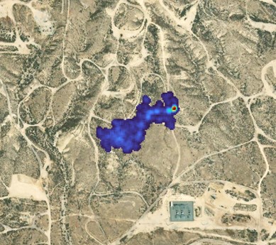
Along with images of methane plumes, commercial plume imaging satellites typically estimate:
- The location of the origin of the plume
- The total concentration of the methane from the sensor to the plume origination at the surface
- The emissions rate when the plume image was taken
Strengths:
- Can detect methane emissions from individual sources
- More frequent observations of large methane sources
- High-spatial resolution (typically 30-40 meter) with the ability to cover large areas
- Detect methane with high sensitivity
Limitations:
- Less likely to detect diffuse area-wide sources of emissions or small point sources than large point sources.
- Clouds and other atmospheric conditions can lead to gaps in data collection.
- Satellites cannot scan “everywhere, every day”, but rather, must be pointed at specific pre-determined areas of interest.